
Monthly Archives: March 2021
Google Maps vs. Waze
I am directionally challenged. Knowing which direction is which does not come naturally to me like it does to my husband, Kenn. I can work out directions if I know the time and can see the sun but that method isn’t particularly helpful in bumper-to-bumper rush hour traffic. In spite of my directionally challangedness my primary function during our travels over the years has been that of navigator. (Many of our biggest traveling arguments have revolved around navigation. Translation: my hubby refusing to follow the directions given.) Map apps were a life changer for people like me.
Over the years, Google Maps has been our go-to map app. Prior to our road trip in 2019 Kenn decided that we should give Waze a try. It took me a bit to get the hang of Waze, but once I did, I really liked it. There are a wide variety of voices to chose from; my favorite was Kate with her proper British accent. (I thought Cookie Monster would be cute. I was wrong. Adding “om nom nom” after everything drove me nuts so the Cookie Monster voice was in use for less than a minute.) Waze has a game-like vibe that allows you to unlock achievements by collecting “candy” for various actions. Waze showing our speed in comparison to the current speed limit was helpful even though it wasn’t enough to keep us from getting a speeding ticket in the mail from Sioux City, Iowa a couple of weeks after we got home. (insert facepalm here) I also like the capability for users to mark and unmark things such as accidents, debris in the road, etc. in real-time. In my opinion, Waze also does a much better job with pronunciations; Google Maps garbles the simplest of names much less complicated ones. The biggest problem we had with Waze was that it relied on the availability of a cell signal instead of GPS. There are a lot of places in this big, beautiful country where there is no cell service; since we were traveling through a lot of those areas, we eventually had to revert back to Google Maps in order to have reliable information.
One of the biggest problems with map apps in general becomes apparent when we are towing our travel trailer. When towing we avoid interstates and big cities as much as possible. However, map apps interpret “avoid highways” as “please take me down every crappy side road possible”. We’ve had Maps try to route us down roads that specifically forbid travel trailers, fire service roads, and a road leading under a railroad track with insufficient clearance for our travel trailer – this in spite of the fact that within sight distance, less than a block away, was a road that went over the railroad tracks. So far, we’ve been able to avoid these potential fiascoes. I’m waiting for the day we make the local news in some town because we’ve brought traffic to a complete halt due to following the directions of our map app. In my opinion, what we really need is either a separate app for those of us towing or a towing option in the current apps that is smart enough to allow us to avoid interstates and those roads that aren’t travel trailer friendly. App developers, are you listening?
Have you had any harrowing experiences due to map apps?
UPDATE: Since I wrote this post I have discovered an app called CoPilot RV that I will be testing out during our trips over the next few months. I’ll let you know what I think.


Review: Stephen C. Foster State Park
If you love the great outdoors and are looking to get away from it all, you can’t do much better than Stephen C. Foster State Park. Stephen C. Foster State Park is located in the Okefenokee National Wildlife Refuge in southern Georgia and is one of the primary entrances to the Okefenokee Swamp. In my last post I told you that Amicalola Falls State Park is my favorite Georgia state park; Stephen C. Foster state park holds the honor of being my second favorite. The two parks couldn’t be more different.

The park is home to many forms of wildlife not the least of which is the American alligator. The park offers guided boat tours of the swamp in addition to kayak and canoe rentals. We took a sunset boat tour during our first stay at the park in 2016 and it was wonderful – except for the yellow flies. (I had thirty bites on one foot/ankle and forty on the other. When they started itching, a week later, I thought I was going to lose my mind.) Unlike many of the other parks we have visited during the pandemic, Stephen C. Foster is continuing to offer both guided boat tours and canoe/kayak rentals; COVID restrictions have reduced the number of people allowed on each of the guided boat tours and all tours were booked during our recent stay.
During our 2016 visit we rented individual kayaks for a two-hour self-guided float in the swamp. This trip, we rented a tandem kayak which worked out well; the arthritis/rotator cuff issues in my shoulders would have prevented me from being able to paddle long on my own. Once again we enjoyed a two-hour self-guided float of a different section of the swamp. We saw several small and medium-sized gators sunning themselves on the banks and heard what we think was a wild hog. I love both the peace and quiet of the swamp and the desolate beauty.

When planning a stay at Stephen C. Foster, you’ll need to go prepared. The park is roughly twenty miles from the nearest town of Fargo, Georgia. Fargo is a tiny town; I think there is one restaurant in the town. In addition to being prepared to fix your own meals rather than eat out, you’ll also need to be prepared to have little to no cell signal. (Our satellite dish couldn’t pick up a signal due to all of the trees.) Stephen C. Foster is also an international dark sky park making it perfect for those who enjoy night photography.
While we were in the area we took a drive to check out Suwannee River State Park in Florida. Suwannee River is a beautiful small park that we have added to our list of places to visit. In addition to finding a new park to visit, this trip also gave me an idea for the perfect gift to give my hubby. Stay tune for details!
Oh, I almost forgot! I drove for an hour on the trip home. I’m slowly becoming less intimidated by this whole driving while towing gig. (Don’t expect me to be driving while towing through bit town/cities anytime soon though. There is still a limit to my bravery.)
Until next time, happy trails!

Review: Amicalola Falls State Park
Amicalola Falls State Park is located in the north Georgia mountains near Dawsonville; it is hands down my favorite Georgia state park. My family and I have gone to Amicalola many times over the years but our recent trip was only the second time we have camped. (For those not a fan of camping, the park also has a lodge and cabins.) Camping at Amicalola is not for the faint of heart; from the park entrance to the campground involves navigating a 25% grade. (Yes, you read that right.) As one of the park rangers once told us, this is where a lot of people discover that their tow vehicle isn’t up to the challenge.
The first time we camped at Amicalola we owned an RPOD 177 that we towed with our Toyota Highlander. The RPOD was near the top of the Highlander’s towing capacity but Bonnie (the Highlander) made it up the incline fine. It was the hairpin turn covered with loose gravel within the campground itself that really got my heart pumping. We made it (obviously) but we also drew a bit of an audience. (“Yeah, that gravel gives a lot of people trouble.”)
Our most recent trip was our first trip with Ruby as our tow vehicle. Ruby hauled our Flagstaff Micro Lite 21FBRS up the 25% incline like it was nothing. Even the ridiculously heavy fog wasn’t enough to stress us out with Ruby on the job. (Can you tell I like my big red truck? LOL.)

The campground itself is relatively small with only 24 campsites and one bath house. However, it is laid out well and the road had been recently paved. There was also no gravel on the hairpin turn this time so it seems that someone finally devised a way to prevent that problem. Even though we arrived in rain and fog (not uncommon when we travel) it moved out overnight so we were able to get out and enjoy the rest of our trip. There are all sorts of things to see and do within the park itself, not the least of which is viewing the falls. Many of the activities and events have currently been curtailed due to COVID-19 so I recommend that you check the website (link at the beginning of this post) for the latest information before traveling.
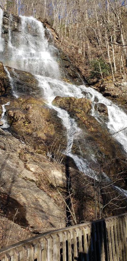
It wouldn’t be a trip to Amicalola without viewing the falls so we did hike the stairs partway down the falls. The stairs at the falls are labeled as “Strenuous” and they are not kidding but there is also an accessible parking lot and trail which allows for viewing without the hike. We ventured out a little further this time and traveled down forestry service roads to reach the trailhead for Long Creek Falls. While the forestry service road itself was in less than stellar shape in some areas the ride was worth it for the winter wonderland of ice-covered trees we discovered at the top of a ridge. (You can see my favorite photo here.) The hike from the trailhead to the falls was approximately one mile and wasn’t strenuous at all. The falls were small but definitely worth the walk.

Right now, I’m a happy girl. I’ve been struggling a bit with the continued self-isolation due to COVID and this was a much needed trip. My soul is always the most at peace in the mountains and being at my favorite park made it even better. *happy sigh*
Now I have to finish packing for our next adventure! Until next time, happy trails!

